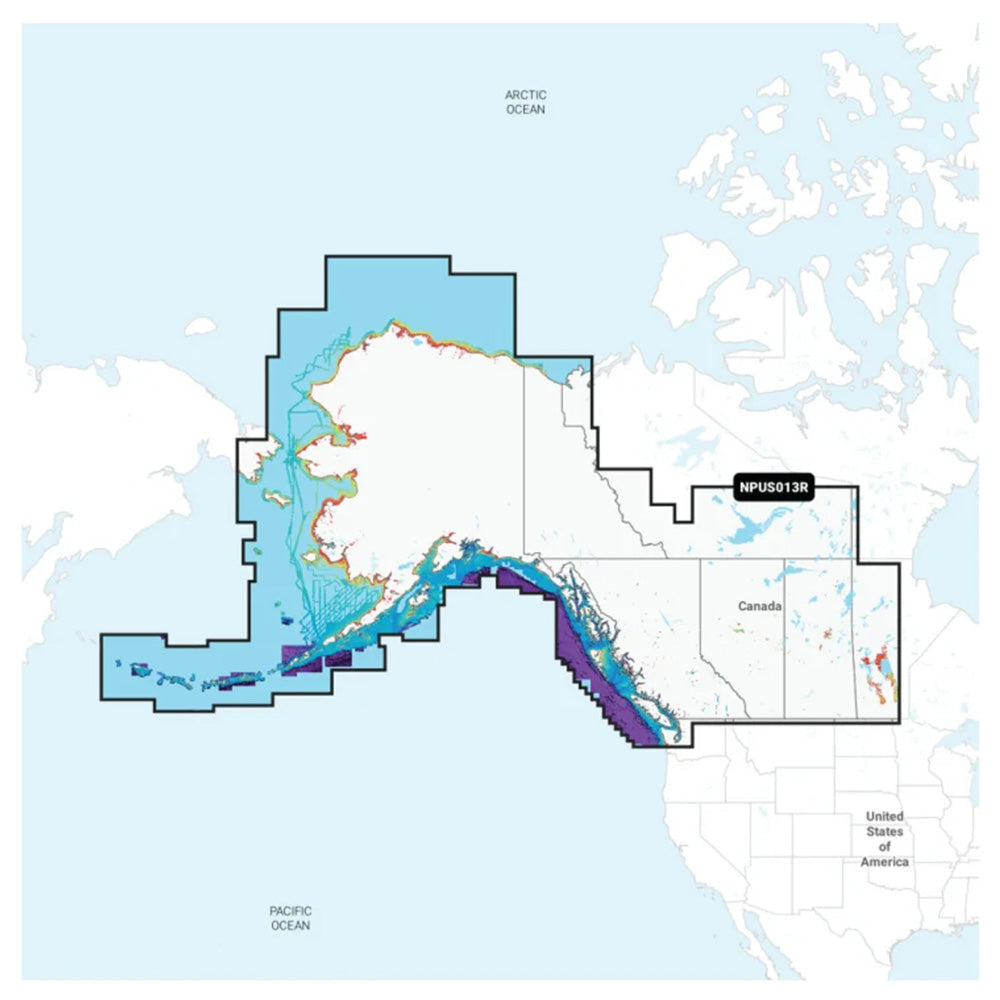
Navionics Platinum+ NPUS013R - Canada, West Alaska
Navionics Platinum+ NPUS013R - Canada, West Alaska is backordered and will ship as soon as it is back in stock.
Product Description
Product Description
Enhance your boating experience with the Navionics Platinum+ NPUS013R, the premier marine mapping solution tailored for Canada, West Coast, and Alaska. Experience unparalleled accuracy and detail with the world’s leading Navionics+ cartography, perfectly integrated with your compatible chartplotter.
Why Choose Navionics Platinum+ NPUS013R?
The Platinum+ NPUS013R offers comprehensive mapping for both offshore and inland waters, including coastal areas, lakes, and rivers. Benefit from SonarChart™ 1’ HD bathymetry maps, advanced dock-to-dock route guidance, live mapping capabilities, and seamless wireless updates through Plotter Sync.
Coverage Area
Enjoy detailed navigation across the expansive waterways of western Canada and Alaska. Key coverage areas include:
- Vancouver Island
- Puget Sound
- Aleutian Islands
Key Features
All-In-One Mapping Solution
Access a rich array of maps covering coastal features, lakes, rivers, and more, compatible with a wide range of chartplotters. Perfect for boaters exploring inland and offshore waters worldwide.
Daily Chart Updates
Stay up-to-date with the latest chart data. A 1-year subscription included with your purchase ensures you receive daily updates via the Navionics Chart Installer software.
Dock-To-Dock Route Guidance
Plan your journeys with ease using advanced route guidance technology. This feature calculates optimal paths through channels, inlets, marina entrances, and other navigational points based on your boat settings and frequently traveled routes.2
High-Resolution Bathymetry and Contours
Navigate confidently with up to 1’ SonarChart™ HD bathymetry maps and detailed contours. These features provide clear bottom structure depictions, enhancing both fishing and navigation in various water conditions.
Advanced Map Customization
Customize your chart view to highlight shallow areas, adjust contour density, or select specific fishing ranges, allowing you to focus on the details that matter most.
Community Edits
Leverage the collective knowledge of the boating community. Download and view local edits made by other Navionics Boating app users directly on your chartplotter.
Plotter Sync
Seamlessly transfer routes, markers, and updates between your plotter card and mobile app wirelessly. Manage your cartography subscription and upload sonar logs effortlessly.4
SonarChart™ Live Mapping
Generate real-time maps as you navigate. Watch new HD bathymetry maps develop dynamically with your boat’s movement.
Enhanced Visualization Options
- High-Resolution Relief Shading: Combines color and shadow for an intuitive view of bottom structures.
- Sonar Imagery: Highlights bottom hardness and transition areas with clear, contrasting colors.5
- High-Resolution Satellite Imagery: Provides realistic surrounding views, ideal for unfamiliar harbors or ports.5
- Aerial Photography: Offers clear photos of navigational landmarks above the waterline.
- 3D View: Enhances situational awareness with perspectives both above and below the water surface.
Technical Specifications
| Format | MicroSD™/SD™ |
|---|---|
| Card Format | MicroSD/SD |
| Box Dimensions | 1"H x 4"W x 6"L |
| Weight | 0.15 lbs |
| UPC | 821245995971 |
Included in the Box
- MicroSD™/SD™ card
Compatibility
Ensure your GPS chartplotter is compatible with Navionics+ content and features. Please verify compatibility before purchase.
Additional Resources
Important Information
- 1Navionics+ and Navionics Platinum+ cards are not compatible with Garmin chartplotters.
- 2Route guidance is for planning purposes only and does not replace safe navigation operations.
- 3Renewing a subscription without lapsing costs up to 50% less than purchasing the same updates and content via a new card or new subscription.
- 4The Plotter Sync feature requires the use of the Navionics Boating app on your compatible smart device with an active subscription in the same area.
- 5Subscription required; a 1-year subscription (included with the purchase of Navionics Platinum+ mapping solution) lets you access daily chart updates and download additional content or premium features included with your cartography product.
Note: This product is sold as an individual unit and may not be returned to the original point of purchase. Please contact the manufacturer directly with any issues or concerns.
Delivery and Shipping
Delivery and Shipping
Orders of physical products placed by 3 PM EST M-F typically ships the same day, if all requested items are in stock. Weekend orders will typically ship on Monday.
Shipping takes 2-7 days.
We currently ship to the Contiguous 48 States.
Life of Sailing merch is custom made for the customer after an order is placed. Total turnaround is typically 7-14 days from order to doorstep.
Payment & Security
Payment methods
Your payment information is processed securely. We do not store credit card details.

