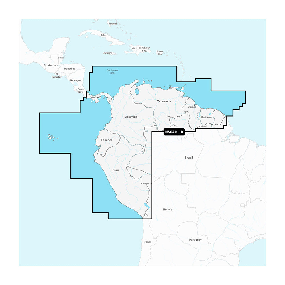
Garmin Navionics+ NSSA011R South America (North)
Garmin Navionics+ NSSA011R South America (North) is backordered and will ship as soon as it is back in stock.
Product Description
Product Description
Enhance your boating adventures with the Navionics+™ NSSA011R South America (North), featuring vibrant colors and a streamlined interface. Designed for seamless navigation, this cartography solution combines coastal and inland content, ensuring you can plot your courses with confidence using the world’s leading marine mapping technology.
Key Features
- Compatible with microSD™ and SD™ formats
- Comprehensive offshore and inland lake coverage tailored for Garmin chartplotters
- Customizable views with various chart layers and overlay options
- Includes a one-year subscription for daily updates via the ActiveCaptain® smart-device app
- Auto Guidance+™ technology2 provides suggested dock-to-dock routes
- Up to 10 color-shaded target depth ranges to identify prime fishing spots
- Cost-effective subscription renewal for continued access to daily updates and new content downloads
Extensive Coverage Areas
Experience detailed mapping along the entire coast of Panama, including the pivotal Panama Canal. Additional coastal coverage includes:
- Peru
- Ecuador
- Colombia
- Venezuela
- Trinidad and Tobago
- Guyana
- Suriname
- French Guiana
All-In-One Map Solution for Garmin Chartplotters
Access comprehensive, detail-rich maps of coastal features, lakes, rivers, and more. The integration of Garmin and Navionics® content ensures worldwide coverage, making it an essential tool for boaters globally.
Daily Chart Updates
Stay up-to-date with the latest marine information. With up to 5,000 updates daily, the included one-year subscription grants access to daily chart updates through the ActiveCaptain app, keeping your navigation data current and reliable.
Auto Guidance+ Technology
Leverage the combined strength of Garmin and Navionics' automatic routing capabilities. The built-in Auto Guidance+ technology2 offers suggested paths from dock to dock, navigating through channels, inlets, marina entrances, and other critical waterways.
Depth Range Shading
Easily identify optimal fishing spots with high-resolution depth range shading. Users can select up to 10 color-shaded depth ranges, providing a clear visual representation of target depths at a glance.
Up to 1’ Contours
Benefit from detailed bottom structure depictions with up to 1-foot contours. This feature enhances fishing charts and provides greater detail in areas such as swamps, canals, harbors, and marinas, improving both navigation and fishing experiences.
Shallow Water Shading
Avoid shallow waters effortlessly. The shallow water shading feature allows users to set a custom depth threshold, clearly highlighting areas to steer clear of for safe navigation.
ActiveCaptain Community
Tap into the power of the ActiveCaptain community. Access community-sourced points of interest (POIs) including marinas, anchorages, hazards, and local businesses. Receive firsthand recommendations and insights from experienced boaters familiar with the local environment.
1 Auto Guidance+ is intended for planning purposes only and does not replace safe navigation operations.
Delivery and Shipping
Delivery and Shipping
Orders of physical products placed by 3 PM EST M-F typically ships the same day, if all requested items are in stock. Weekend orders will typically ship on Monday.
Shipping takes 2-7 days.
We currently ship to the Contiguous 48 States.
Life of Sailing merch is custom made for the customer after an order is placed. Total turnaround is typically 7-14 days from order to doorstep.
Payment & Security
Payment methods
Your payment information is processed securely. We do not store credit card details.

